Sentinel-1
Mission and sensor parameters
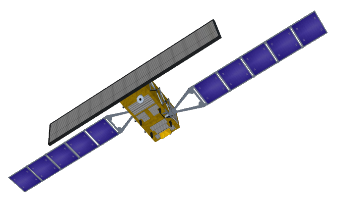
Sentinel-1 is an operational C-band radar earth observation satellite which is part of Copernicus: the Earth observation component of the European Union's Space programme1. The Sentinel-1 mission comprises a constellation of two polar-orbiting satellites, operating day and night performing C-band synthetic aperture radar imaging, enabling them to acquire imagery regardless of the weather.
Mission parameters
Sentinel-1A was launched on 3 April 2014, Sentinel-1B on 25 April 2016, and Sentinel-1C on 5 December 2024. Each satellite carries a single C-band SAR instrument (5.405 GHz centre frequency) which provides imagery in dual polarisation (HH+HV, VV+VH). Once launched, the European Commission assumes ownership of the satellites, and the European Space Agency the role of operator. In the Charter Governance ESA acts as mission owner of Sentinel-1.
Table 1 provides a summary of the Sentinel-1 mission.
| Parameter | Specifications |
|---|---|
| EO Mission | Sentinel-1 |
| Charter Owner Agency | ESA |
| Providing Agency | Copernicus, ESA |
| Date of launch | 2014-04-03 |
| Temporal coverage | 2015-04-12 - present |
| Mission status | Operational |
| Mission Life Expected | >10 years |
| Orbit Type | Sun-synchronous |
| Local Time | 18:00 ascending node |
| Orbit Height | 693 km |
| Orbit Period | 98.6 min |
| Repeat Cycle | 12 days at Equator with one satellite |
| Ref. tube deviation | +/- 100m |
Note
On 23 December 2021, the Sentinel-1B spacecraft experienced an anomaly which resulted in a loss of data transmission.
Sensor specifications
Table 2 provides specifications of the C-SAR instrument, an active phased array antenna, on board the Sentinel-1 platform.
| Parameter | Specifications |
|---|---|
| Center frequency | 5.405 GHz (C-band) |
| Bandwidth | 0-100 MHz |
| Look direction | Right |
| Incidence angle range | 20-46° |
| Polarization | HH+HV, VV+VH, VV, HH |
| Imaging Modes | SM, IW, EW, WV imaging modes |
| Resolution | Low Resolution - S-LR (10 - 35m) |
| Swath width | Up to 410 km |
Acquisitions modes and polarizations
Sentinel-1 SAR acquistion imaging modes are:
-
Stripmap(SM) -
Interferometric Wide Swath(IW) -
Extra Wide Swath(EW) -
Wave(WV).
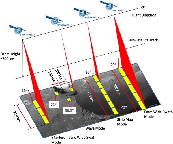
The SM, IW, and EW modes support operation in selectable single polarisation (HH or VV) and dual polarisation (HH+HV, VV+VH).
Table 3 provides the characteristics of Sentinel-1 acquisition modes.
| Acquisitions mode | Swath width | Incidence angle | Spatial resolution |
|---|---|---|---|
| SM | 80 km | 18.3-46.8° | 5x5m |
| IW | 250 km | 9.1-46° | 5x20m |
| EW | 410 km | 18.9-47° | 20x40m |
| WV | 20x20 km | 21.6-25.1°, 34.8-38.0° | 5x5m |
Polarisation options are: Dual HH+HV, VV+VH Single HH, VV. Maximum Noise Equivalent Sigma Zero (NESZ) is of -22 dB. Subswath for IW and EW are respectively, 3 and 5.
Note
Sentinel-1 products received in the Charter are mostly given IW mode.
Processing levels
Sentinel-1 EO data are distributed at three levels of processing: L0, L1, L2. In the charter Sentinel-1 products are given at L1 in the following 2 product types:
-
Single Look Complex (SLC)L1 data: complex images with phase and amplitude of specified areas -
Ground Range Detected (GRD)L1 data: only systematically distributed multi-looked intensity
SLC
Level-1 SLC products are images in the slant range by azimuth imaging plane, in the image plane of satellite data acquisition. Each image pixel is represented by a complex (I and Q) magnitude value and therefore contains both amplitude and phase information. Each I and Q value is 16 bits per pixel. SLC products are generated for all acquisition modes.
| Characteristic | Value |
|---|---|
| Pixel value | Complex |
| Coordinate system | Slant range |
| Bits per pixel | 16 I and 16 Q |
| Polarisation options | Single (HH or VV) or Dual (HH+HV or VV+VH) |
| ENL | 1 |
| Number of looks (rg x az) | 1 x 1 |
Note
Sentinel-1 SLC products received in the Charter are mostly given in IW mode.
GRD
Level-1 GRD products are available in one of three spatial resolutions:
-
Full Resolution(FR) for SM mode -
High Resolution(HR) for SM, IW and EW modes -
Medium Resolution(MR) for SM, IW, EW and WV modes.
Resolution, pixel spacing, number of looks, ENL for Sentinel-1 SLC/GRD products can be found in Table 5 for each resolution class.
| Acq. Mode | Product Type | Resolution Class | Resolution Rg x Az [m] | Pixel Spacing Rg x Az [m] | Num Looks Rg x Az | <ENL |
|---|---|---|---|---|---|---|
| SM | SLC | - | 1.7x4.3 to 3.6x4.9 | 1.5x3.6 to 3.1x4.1 | 1x1 | 1 |
| GRD | FR | 9x9 | 3.5x3.5 | 2x2 | 3.7 | |
| HR | 23x23 | 10x10 | 6x6 | 29.7 | ||
| MR | 84x84 | 40x40 | 22x22 | 398.4 | ||
| IW | SLC | - | 2.7x22 to 3.5x22 | 2.3x14.1 | 1x1 | 1 |
| GRD | HR | 20x22 | 10x10 | 5x1 | 4.4 | |
| MR | 88x87 | 40x40 | 22x5 | 81.8 | ||
| EW | SLC | - | 7.9x43 to 15x43 | 5.9x19.9 | 1x1 | 1 |
| GRD | HR | 50x50 | 25x25 | 3x1 | 2.8 | |
| MR | 93x87 | 40x40 | 6x2 | 10.7 | ||
| WV | SLC | - | 2.0x4.8 to 3.1x4.8 | 1.7x4.1 to 2.7x4.1 | 1x1 | 1 |
| GRD | MR | 52x51 | 25x25 | 13x13 | 123.7 |
Note
Sentinel-1 GRD products received in the Charter are mostly given at High Resolution.
Ingested format
Information extracted from product annotation included in the STAC item of a Sentinel-1 GRD dataset are listed below.
Properties
STAC item content about properties for a Sentinel-1 GRD HR IW VV/VH Dataset is the following:
  "properties": {
    "datetime": "2022-10-11T11:29:01.526969Z",
    "start_datetime": "2022-10-11T11:29:01.526969Z",
    "end_datetime": "2022-10-11T11:29:26.525849Z",
    "created": "2022-10-12T10:05:46.5746468Z",
    "updated": "2023-08-23T15:57:26.8630676Z",
    "platform": "sentinel-1a",
    "constellation": "sentinel-1",
    "mission": "sentinel-1",
    "instruments": [
      "c-sar"
    ],
    "sensor_type": "radar",
    "gsd": 22,
    "title": "SENTINEL-1A GRD VV/VH 172 2022-10-11 11:29:01",
    "providers": [
      {
        "name": "ESA",
        "roles": [
          "licensor"
        ]
      }
    ],
    "license": "CC-BY-SA-3.0-IGO",
    "disaster:call_ids": [
      903
    ],
    "disaster:resolution_class": "LR",
    "cpe:cos2_id": "903-ESA-SENTINEL_1A-S1A_IW_GRDH_1SDV_20221011T112901_20221011T112926_045394_056D8C_1BE7.SAFE.zip",
  }
Satellite
STAC item content about Satellite for a Sentinel-1 GRD HR IW VV/VH Dataset is the following:
  "properties": {
    "sat:orbit_state": "ascending",
    "sat:anx_datetime": "2022-10-11T09:47:06.522627Z",
    "sat:absolute_orbit": 45394,
    "sat:relative_orbit": 172,
    "sat:platform_international_designator": "2014-016A"
}
SAR
STAC item content about SAR for a Sentinel-1 GRD HR IW VV/VH Dataset is the following:
  "properties": {
    "sar:instrument_mode": "IW",
    "sar:frequency_band": "C",
    "sar:polarizations": [
      "VV",
      "VH"
    ],
    "sar:product_type": "GRD"
}
Processing
STAC item content about Processing for a Sentinel-1 GRD HR IW VV/VH Dataset is the following:
  "properties": {
    "processing:level": "L1",
    "processing:lineage": "GRD Post Processing",
    "processing:facility": "Copernicus Ground Segment",
    "processing:software": {
      "Sentinel-1 IPF": "003.52"
    },
  }
Projection
STAC item content about Projection for a Sentinel-1 GRD HR IW VV/VH Dataset is the following:
  "properties": {
      "proj:shape": [
        25689,
        16764
      ]
  }
Geometry
STAC item content about Geometry for a Sentinel-1 GRD HR IW VV/VH Dataset is the following:
  "geometry": {
    "type": "Polygon",
    "coordinates": [
      [
        [
          99.434959,
          13.719059
        ],
        [
          99.74543,
          12.207163
        ],
        [
          102.063171,
          12.657678
        ],
        [
          101.767723,
          14.165735
        ],
        [
          99.434959,
          13.719059
        ]
      ]
    ]
  },
  "bbox": [
    99.434959,
    12.207163,
    102.063171,
    14.165735
  ]
Assets
STAC item content about assets (annotation, quicklooks and spectral bands files harvested from the source product) for a Sentinel-1 GRD HR IW VV/VH Dataset is the following:
  "assets": {
    "amplitude-vh-iw-002": {
      "type": "image/x.geotiff",
      "roles": [
        "amplitude",
        "data"
      ],
      "title": "IW VH Amplitude pixel values",
      "href": "https://.../S1A_IW_GRDH_1SDV_20221011T112901_20221011T112926_045394_056D8C_1BE7/amplitude-vh-iw-002.tiff",
      "filename": "S1A_IW_GRDH_1SDV_20221011T112901_20221011T112926_045394_056D8C_1BE7.SAFE/measurement/s1a-iw-grd-vh-20221011t112901-20221011t112926-045394-056d8c-002.tiff",
      "file:size": 861579876,
      "sar:polarizations": [
        "VH"
      ],
      "proj:epsg": null,
      "proj:shape": [
        25689,
        16764
      ]
    },
    "annotation-vh-iw-002": {
      "type": "text/xml",
      "roles": [
        "metadata"
      ],
      "title": "Annotation VH IW 002",
      "href": "https://.../S1A_IW_GRDH_1SDV_20221011T112901_20221011T112926_045394_056D8C_1BE7/annotation-vh-iw-002.xml",
      "filename": "S1A_IW_GRDH_1SDV_20221011T112901_20221011T112926_045394_056D8C_1BE7.SAFE/annotation/s1a-iw-grd-vh-20221011t112901-20221011t112926-045394-056d8c-002.xml",
      "file:size": 1910546,
      "sar:polarizations": [
        "VH"
      ]
    },
    "amplitude-vv-iw-001": {
      "type": "image/x.geotiff",
      "roles": [
        "amplitude",
        "data"
      ],
      "title": "IW VV Amplitude pixel values",
      "href": "https://.../S1A_IW_GRDH_1SDV_20221011T112901_20221011T112926_045394_056D8C_1BE7/amplitude-vv-iw-001.tiff",
      "filename": "S1A_IW_GRDH_1SDV_20221011T112901_20221011T112926_045394_056D8C_1BE7.SAFE/measurement/s1a-iw-grd-vv-20221011t112901-20221011t112926-045394-056d8c-001.tiff",
      "file:size": 861579876,
      "sar:polarizations": [
        "VV"
      ],
      "proj:epsg": null,
      "proj:shape": [
        25689,
        16764
      ]
    },
    "annotation-vv-iw-001": {
      "type": "text/xml",
      "roles": [
        "metadata"
      ],
      "title": "Annotation VV IW 001",
      "href": "https://.../S1A_IW_GRDH_1SDV_20221011T112901_20221011T112926_045394_056D8C_1BE7/annotation-vv-iw-001.xml",
      "filename": "S1A_IW_GRDH_1SDV_20221011T112901_20221011T112926_045394_056D8C_1BE7.SAFE/annotation/s1a-iw-grd-vv-20221011t112901-20221011t112926-045394-056d8c-001.xml",
      "file:size": 1910546,
      "sar:polarizations": [
        "VV"
      ]
    },
    "calibration-vh-iw-002": {
      "type": "text/xml",
      "roles": [
        "calibration",
        "data"
      ],
      "title": "Calibration VH IW",
      "href": "https://.../S1A_IW_GRDH_1SDV_20221011T112901_20221011T112926_045394_056D8C_1BE7/calibration-vh-iw-002.xml",
      "filename": "S1A_IW_GRDH_1SDV_20221011T112901_20221011T112926_045394_056D8C_1BE7.SAFE/annotation/calibration/calibration-s1a-iw-grd-vh-20221011t112901-20221011t112926-045394-056d8c-002.xml",
      "file:size": 1010137,
      "sar:polarizations": [
        "VH"
      ]
    },
    "calibration-vv-iw-001": {
      "type": "text/xml",
      "roles": [
        "calibration",
        "data"
      ],
      "title": "Calibration VV IW",
      "href": "https://.../S1A_IW_GRDH_1SDV_20221011T112901_20221011T112926_045394_056D8C_1BE7/calibration-vv-iw-001.xml",
      "filename": "S1A_IW_GRDH_1SDV_20221011T112901_20221011T112926_045394_056D8C_1BE7.SAFE/annotation/calibration/calibration-s1a-iw-grd-vv-20221011t112901-20221011t112926-045394-056d8c-001.xml",
      "file:size": 1010137,
      "sar:polarizations": [
        "VV"
      ]
    },
    "noise-vh-iw-002": {
      "type": "text/xml",
      "roles": [
        "data",
        "noise"
      ],
      "title": "Noise VH IW",
      "href": "https://.../S1A_IW_GRDH_1SDV_20221011T112901_20221011T112926_045394_056D8C_1BE7/noise-vh-iw-002.xml",
      "filename": "S1A_IW_GRDH_1SDV_20221011T112901_20221011T112926_045394_056D8C_1BE7.SAFE/annotation/calibration/noise-s1a-iw-grd-vh-20221011t112901-20221011t112926-045394-056d8c-002.xml",
      "file:size": 412712,
      "sar:polarizations": [
        "VH"
      ]
    },
    "noise-vv-iw-001": {
      "type": "text/xml",
      "roles": [
        "data",
        "noise"
      ],
      "title": "Noise VV IW",
      "href": "https://.../S1A_IW_GRDH_1SDV_20221011T112901_20221011T112926_045394_056D8C_1BE7/noise-vv-iw-001.xml",
      "filename": "S1A_IW_GRDH_1SDV_20221011T112901_20221011T112926_045394_056D8C_1BE7.SAFE/annotation/calibration/noise-s1a-iw-grd-vv-20221011t112901-20221011t112926-045394-056d8c-001.xml",
      "file:size": 412712,
      "sar:polarizations": [
        "VV"
      ]
    },
    "manifest": {
      "type": "text/xml",
      "roles": [
        "metadata"
      ],
      "title": "SAFE Manifest",
      "href": "https://.../S1A_IW_GRDH_1SDV_20221011T112901_20221011T112926_045394_056D8C_1BE7/manifest.safe",
      "filename": "S1A_IW_GRDH_1SDV_20221011T112901_20221011T112926_045394_056D8C_1BE7.SAFE/manifest.safe",
      "file:size": 24005
    }
  }
Product Calibration
For Sentinel-1 products calibration refer to the Radar Products Calibration (SAR-Calib) service and the calibration sheet available here.
-
ESA, Sentinel Online, Sentinel-1 Mission Guide. Available at: sentinel.esa.int ↩