WorldView-3
WorldView-3 L1B panchromatic and multispectral EO data products are calibrated using the Optical Products Calibration (OPT-Calib) service.
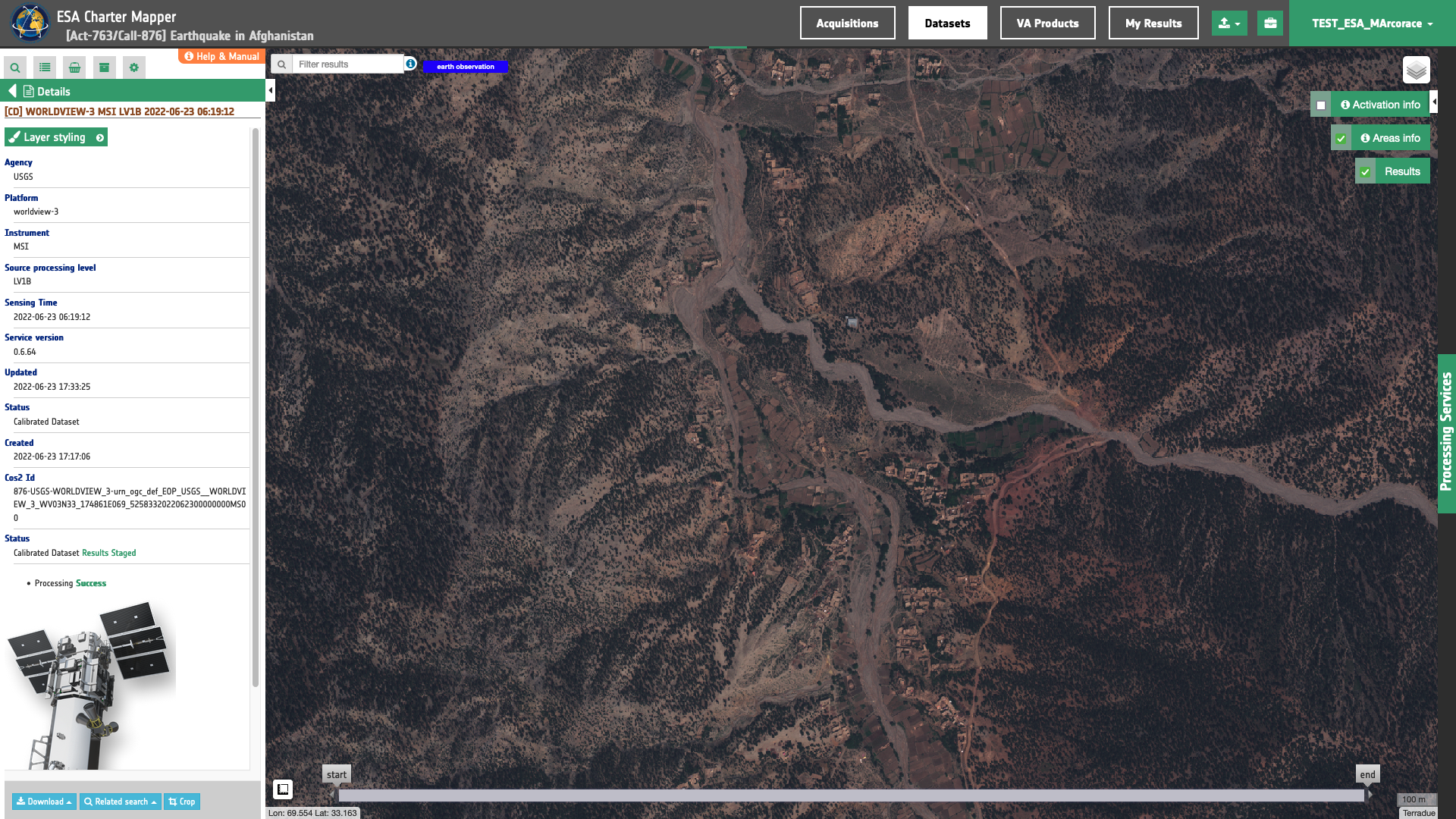
Figure 1 - True Color composite derived from Worldview-3 L1B calibrated data acquired on 23/06/2023 over Spera District, Khost Province, Afghanistan. Credits: DigitalGlobe, USGS.
The process applied is the same for PAN and MS acquisitions.
Input
The input is an ingested WorldView-3, find details here.
DN to Radiance
The WorldView-3 product handbook1 provides the formula below to convert the DN into radiance:
Where:
\(gain_{(b)}\) and \(offset_{(b)}\) are values taken from Table 1:
| Common band name | Gain | Offset |
|---|---|---|
| pan | 0.950 | -3.629 |
| coastal | 0.905 | -8.604 |
| blue | 0.940 | -5.809 |
| green | 0.938 | -4.996 |
| yellow | 0.962 | -3.649 |
| red | 0.964 | -3.021 |
| rededge | 1.000 | -4.521 |
| nir08 | 0.961 | -5.522 |
| nir09 | 0.978 | -2.992 |
And \(abscalfactor\) and \(effectivebandwith\) are extracted from the acquisition metadata.
The conversion from \(DN\) (for Digital Numbers) to spectral radiance (or ‘TOA radiance’) \(L \) is done with the formula below:
As such, the calibration uses:
and
\(L \) in \(W/m^2/steradians/micrometers\) with \(b\) being a band ID.
Radiance to Reflectance
To convert TOA radiance to TOA reflectance, the following formula is used :
where :
-
\(L(b)\) is the spectral radiance for band b
-
\(pi\) is the famous mathematical constant
-
\(d\) is the earth-sun distance (in astronomical units) and depends on the acquisition’s day and month
-
\(ESUN(b)\) is the mean TOA solar irradiance (or solar illumination) in \(W/m^2/micrometers\)
-
\(θ\) is the solar zenith angle in degrees.
The conversion from elevation angle to solar zenith angle \(θ\) (in degrees) is:
The values for the \(ESUN(b)\) are provided in Table 2:
| Common band name | Thuillier 2003 |
|---|---|
| pan | 1574.41 |
| coastal | 1757.89 |
| blue | 2004.61 |
| green | 1830.18 |
| yellow | 1712.07 |
| red | 1535.33 |
| rededge | 1348.08 |
| nir08 | 1055.94 |
| nir09 | 858.77 |
Output
The output is a STAC item GeoJSON2 including the assets shown below
  "assets": {
    "coastal": {
      "type": "image/tiff; application=geotiff",
      "roles": [
        "data",
        "reflectance",
        "visual"
      ],
      "href": "https://.../WV03N33_174861E069_5258332022062300000000MS00-calibrated/coastal.tif",
      "eo:bands": [
        {
          "name": "coastal",
          "common_name": "coastal",
          "center_wavelength": 0.4274,
          "solar_illumination": 1757.89,
          "full_width_half_max": 0.02025
        }
      ],
      "raster:bands": [
        {
          "spatial_resolution": 0.0000147646949405,
          "statistics": {
            "minimum": "0",
            "maximum": "6347",
            "mean": "854.39426479578",
            "stddev": "551.85802604088",
            "valid_percent": "100"
          },
      "file:size": 91755870
    },
    "red": {
      "type": "image/tiff; application=geotiff",
      "roles": [
        "data",
        "reflectance",
        "visual"
      ],
      "href": "https://.../WV03N33_174861E069_5258332022062300000000MS00-calibrated/red.tif",
      "eo:bands": [
        {
          "name": "red",
          "common_name": "red",
          "center_wavelength": 0.6601,
          "solar_illumination": 1535.33,
          "full_width_half_max": 0.02925
        }
      ],
      "raster:bands": [
        {
          "spatial_resolution": 0.0000147646949405,
          "statistics": {
            "minimum": "0",
            "maximum": "9597",
            "mean": "781.44649721892",
            "stddev": "601.396273167",
            "valid_percent": "100"
          },
          "histogram": {
            "count": 256,
            "min": -18.81764705882353,
            "max": 9615.817647058824,
          }
        }
      ],
      "file:size": 120220176
    },
    "blue": {
      "type": "image/tiff; application=geotiff",
      "roles": [
        "data",
        "reflectance",
        "visual"
      ],
      "href": "https://.../WV03N33_174861E069_5258332022062300000000MS00-calibrated/blue.tif",
      "eo:bands": [
        {
          "name": "blue",
          "common_name": "blue",
          "center_wavelength": 0.4819,
          "solar_illumination": 2004.61,
          "full_width_half_max": 0.027
        }
      ],
      "raster:bands": [
        {
          "spatial_resolution": 0.0000147646949405,
          "statistics": {
            "minimum": "0",
            "maximum": "7645",
            "mean": "787.38125030186",
            "stddev": "537.64898625588",
            "valid_percent": "100"
          },
          "histogram": {
            "count": 256,
            "min": -14.990196078431373,
            "max": 7659.990196078431,
          }
        }
      ],
      "file:size": 103085046
    },
    "yellow": {
      "type": "image/tiff; application=geotiff",
      "roles": [
        "data",
        "reflectance",
        "visual"
      ],
      "href": "https://.../WV03N33_174861E069_5258332022062300000000MS00-calibrated/yellow.tif",
      "eo:bands": [
        {
          "name": "yellow",
          "common_name": "yellow",
          "center_wavelength": 0.6043,
          "solar_illumination": 1712.07,
          "full_width_half_max": 0.01905
        }
      ],
      "raster:bands": [
        {
          "spatial_resolution": 0.0000147646949405,
          "statistics": {
            "minimum": "0",
            "maximum": "6683",
            "mean": "739.05154238735",
            "stddev": "552.66287363469",
            "valid_percent": "100"
          },
          "histogram": {
            "count": 256,
            "min": -13.10392156862745,
            "max": 6696.103921568628,
          }
        }
      ],
      "file:size": 118063652
    },
    "rededge": {
      "type": "image/tiff; application=geotiff",
      "roles": [
        "data",
        "reflectance",
        "visual"
      ],
      "href": "https://.../WV03N33_174861E069_5258332022062300000000MS00-calibrated/rededge.tif",
      "eo:bands": [
        {
          "name": "rededge",
          "common_name": "rededge",
          "center_wavelength": 0.7227,
          "solar_illumination": 1348.08,
          "full_width_half_max": 0.01935
        }
      ],
      "raster:bands": [
        {
          "spatial_resolution": 0.0000147646949405,
          "statistics": {
            "minimum": "0",
            "maximum": "7853",
            "mean": "887.91057425555",
            "stddev": "627.02772123954",
            "valid_percent": "100"
          },
          "histogram": {
            "count": 256,
            "min": -15.398039215686275,
            "max": 7868.398039215686,
          }
        }
      ],
      "file:size": 124186124
    },
    "green": {
      "type": "image/tiff; application=geotiff",
      "roles": [
        "data",
        "reflectance",
        "visual"
      ],
      "href": "https://.../WV03N33_174861E069_5258332022062300000000MS00-calibrated/green.tif",
      "eo:bands": [
        {
          "name": "green",
          "common_name": "green",
          "center_wavelength": 0.5471,
          "solar_illumination": 1830.18,
          "full_width_half_max": 0.0309
        }
      ],
      "raster:bands": [
        {
          "spatial_resolution": 0.0000147646949405,
          "statistics": {
            "minimum": "0",
            "maximum": "7279",
            "mean": "744.49282038834",
            "stddev": "537.28707470685",
            "valid_percent": "100"
          },
          "histogram": {
            "count": 256,
            "min": -14.272549019607844,
            "max": 7293.272549019608,
          }
        }
      ],
      "file:size": 119246699
    },
    "nir09": {
      "type": "image/tiff; application=geotiff",
      "roles": [
        "data",
        "reflectance",
        "visual"
      ],
      "href": "https://.../WV03N33_174861E069_5258332022062300000000MS00-calibrated/nir09.tif",
      "eo:bands": [
        {
          "name": "nir09",
          "common_name": "nir09",
          "center_wavelength": 0.9136,
          "solar_illumination": 858.77,
          "full_width_half_max": 0.04445
        }
      ],
      "raster:bands": [
        {
          "spatial_resolution": 0.0000147646949405,
          "statistics": {
            "minimum": "0",
            "maximum": "6455",
            "mean": "949.00748966677",
            "stddev": "653.75464762957",
            "valid_percent": "100"
          },
          "histogram": {
            "count": 256,
            "min": -12.656862745098039,
            "max": 6467.656862745098,
          }
        }
      ],
      "file:size": 125324505
    },
    "nir08": {
      "type": "image/tiff; application=geotiff",
      "roles": [
        "data",
        "reflectance",
        "visual"
      ],
      "href": "https://.../WV03N33_174861E069_5258332022062300000000MS00-calibrated/nir08.tif",
      "eo:bands": [
        {
          "name": "nir08",
          "common_name": "nir08",
          "center_wavelength": 0.824,
          "solar_illumination": 1055.94,
          "full_width_half_max": 0.0502
        }
      ],
      "raster:bands": [
        {
          "spatial_resolution": 0.0000147646949405,
          "statistics": {
            "minimum": "0",
            "maximum": "9543",
            "mean": "1135.7010306127",
            "stddev": "787.44611040581",
            "valid_percent": "100"
          },
          "histogram": {
            "count": 256,
            "min": -18.711764705882352,
            "max": 9561.711764705882,
          }
        }
      ],
      "file:size": 127019973
    },
    "overview-trc": {
      "type": "image/tiff; application=geotiff",
      "roles": [
        "composite",
        "reflectance",
        "visual"
      ],
      "href": "https://.../WV03N33_174861E069_5258332022062300000000MS00-calibrated/overview-trc.tif",
      "raster:bands": [
        {
          "spatial_resolution": 0.0000147646949405,
          "statistics": {
            "minimum": "0",
            "maximum": "254",
            "mean": "53.662709830289",
            "stddev": "42.936631425032",
            "valid_percent": "100"
          },
          "histogram": {
            "count": 256,
            "min": -0.5,
            "max": 255.5,
          }
        },
        {
          "spatial_resolution": 0.0000147646949405,
          "statistics": {
            "minimum": "0",
            "maximum": "253",
            "mean": "50.487792319208",
            "stddev": "37.664632349125",
            "valid_percent": "100"
          },
          "histogram": {
            "count": 256,
            "min": -0.5,
            "max": 255.5,
          }
        },
        {
          "spatial_resolution": 0.0000147646949405,
          "statistics": {
            "minimum": "0",
            "maximum": "253",
            "mean": "53.685524163955",
            "stddev": "37.257732058376",
            "valid_percent": "100"
          },
          "histogram": {
            "count": 256,
            "min": -0.5,
            "max": 255.5,
          }
        },
        {
          "spatial_resolution": 0.0000147646949405,
          "statistics": {
            "minimum": "0",
            "maximum": "255",
            "mean": "188.48946167463",
            "stddev": "111.96667166902",
            "valid_percent": "100"
          },
          "histogram": {
            "count": 256,
            "min": -0.5,
            "max": 255.5,
          }
        }
      ],
      "file:size": 210190269
    },
    "overview-wad": {
      "type": "image/tiff; application=geotiff",
      "roles": [
        "composite",
        "reflectance",
        "visual"
      ],
      "href": "https://.../WV03N33_174861E069_5258332022062300000000MS00-calibrated/overview-wad.tif",
      "raster:bands": [
        {
          "spatial_resolution": 0.0000147646949405,
          "statistics": {
            "minimum": "0",
            "maximum": "253",
            "mean": "50.487792319208",
            "stddev": "37.664632349125",
            "valid_percent": "100"
          },
          "histogram": {
            "count": 256,
            "min": -0.5,
            "max": 255.5,
          }
        },
        {
          "spatial_resolution": 0.0000147646949405,
          "statistics": {
            "minimum": "0",
            "maximum": "253",
            "mean": "53.685524163955",
            "stddev": "37.257732058376",
            "valid_percent": "100"
          },
          "histogram": {
            "count": 256,
            "min": -0.5,
            "max": 255.5,
          }
        },
        {
          "spatial_resolution": 0.0000147646949405,
          "statistics": {
            "minimum": "0",
            "maximum": "251",
            "mean": "59.08198349908",
            "stddev": "38.370765697974",
            "valid_percent": "100"
          },
          "histogram": {
            "count": 256,
            "min": -0.5,
            "max": 255.5,
          }
        },
        {
          "spatial_resolution": 0.0000147646949405,
          "statistics": {
            "minimum": "0",
            "maximum": "255",
            "mean": "188.48946167463",
            "stddev": "111.96667166902",
            "valid_percent": "100"
          },
          "histogram": {
            "count": 256,
            "min": -0.5,
            "max": 255.5,
          }
        }
      ],
      "file:size": 194843970
    },
    "overview-trc-low-res": {
      "type": "image/tiff; application=geotiff",
      "roles": [
        "composite",
        "overview",
        "reflectance"
      ],
      "href": "https://.../WV03N33_174861E069_5258332022062300000000MS00-calibrated/overview-trc-low-res.tif",
      "raster:bands": [
        {
          "spatial_resolution": 0.0001712070192611,
          "statistics": {
            "minimum": "0",
            "maximum": "253",
            "mean": "53.602964401245",
            "stddev": "42.907030195412",
            "valid_percent": "100"
          },
          "histogram": {
            "count": 256,
            "min": -0.5,
            "max": 255.5,
          }
        },
        {
          "spatial_resolution": 0.0001712070192611,
          "statistics": {
            "minimum": "0",
            "maximum": "252",
            "mean": "50.43909740448",
            "stddev": "37.639390122484",
            "valid_percent": "100"
          },
          "histogram": {
            "count": 256,
            "min": -0.5,
            "max": 255.5,
          }
        },
        {
          "spatial_resolution": 0.0001712070192611,
          "statistics": {
            "minimum": "0",
            "maximum": "252",
            "mean": "53.643088340759",
            "stddev": "37.23933497564",
            "valid_percent": "100"
          },
          "histogram": {
            "count": 256,
            "min": -0.5,
            "max": 255.5,
          }
        },
        {
          "spatial_resolution": 0.0001712070192611,
          "statistics": {
            "minimum": "0",
            "maximum": "255",
            "mean": "188.43219280243",
            "stddev": "111.99784765917",
            "valid_percent": "100"
          },
          "histogram": {
            "count": 256,
            "min": -0.5,
            "max": 255.5,
          }
        }
      ],
      "file:size": 4197770
    }
  }
-
Kuester, M. Absolute Radiometric Calibration: 2016v0; updated on 6/6/2017 GE01 and CAVIS, DigitalGlobe: Westminster, CO, USA, 2017; pp. 1–8. ↩
-
Radiant Earth Foundation, STAC item specifications, a single spatiotemporal asset as a GeoJSON feature plus datetime and links, available at:https://github.com ↩