Amazonia-1
Mission description
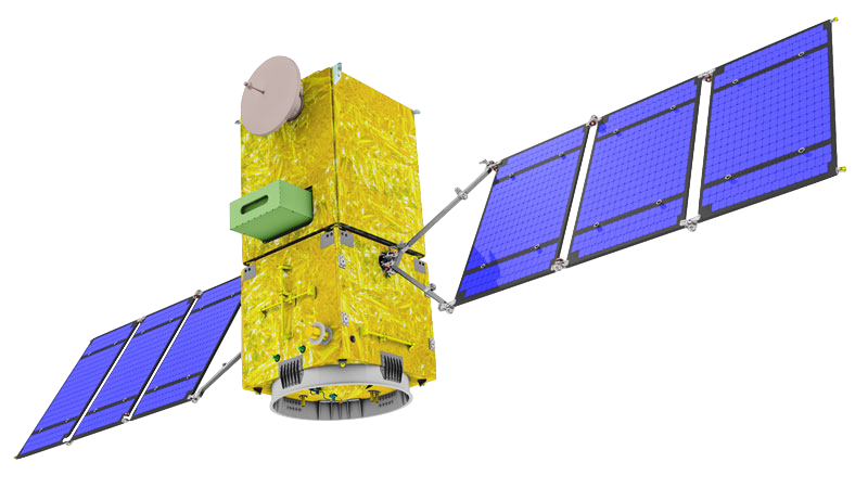
Amazonia-1 is an Earth observation minisatellite mission of the Brazilian Space Agency (AEB), coordinated by the Ministry of Science, Technology and Innovations (MCTI), and developed at the National Institute for Space Research (INPE) in Brazil. The Amazonia series satellites are fully developed in Brazil and use a Multi-Mission Platform. This platform provides the common parts of a satellite and couples different instruments.
Amazonia-1 carries the WFI camera to ensure compatibility and high temporal repeatability with the same cameras on CBERS-4 and CBERS-4A. Amazonia-1 was launched on February 28, 2021, from Satish Dhawan Space Centre (SHAR) in India, and its commissioning phase will be finished by May, 2021. For disaster response by the Charter, the combination of WFI images from three satellites will ensure almost daily coverage of the world at the 60-meter spatial resolution range1,2.
Launched in February 2021, its main goal is to monitor global deforestation, with a focus on the Brazilian Amazon rainforest. Table 1 provides a summary of the Amazonia-1 mission.
| Parameter | Specifications |
|---|---|
| EO Mission | Amazonia-1 |
| Mission Short name | Amazonia-1 |
| Charter Owner Agency | INPE |
| Providing Agency | MCTI, AEB, INPE |
| Date of launch | 28/02/2021 |
| Temporal coverage | 2021 - present |
| Mission status | onGoing |
| End of Life Expected | 28/02/2025 |
| Orbit Height | 752 km |
| Inclination | 98.4 deg |
Table 1 - Amazonia-1 mission parameters.
Instrument
Amazonia-1 is equipped with the multispectral radiometer WFI (Wide Field Imager), which monitors the Amazon vegetation and the coastal environment, being able to detect the extent of rainforest fires. It is also used for measuring the land cover and land mapping. The WFI instrument operates in three visible wavebands (0.45 - 0.50 µm, 0.52 - 0.57 µm, 0.63 - 0.69 µm), as well as in the near-infrared range 0.76 - 0.90 µm. It has a spatial resolution of 60 m at all wavelengths and a swath width of 740 km. Table 2 describes the EO sensor on board of Amazonia-1 satellite, spectral modes and combinations.
| Acronym | Sensor name | Spectral Combination |
|---|---|---|
| WFI | Wide Field Camera | Multispectral 4 bands (Blue, Green, Red and NIR) |
Table 2 - Amazonia-1 earth observation sensor.
Table 3 describes the spectral combinations of the Amazonia-1 products often received in the Charter
| Instrument | Spectral combinations |
|---|---|
| WFI | Multispectral 4 bands: BAND13 (Blue), BAND14 (Green), BAND15 (Red), BAND16 (NIR) |
Table 3 - Spectral combinations for most recurrent Amazonia-1 products in the charter.
Spectral modes and bands
WFI
Table 4 reports technical specifications for the Amazonia WFI instrument.
| Parameter | Specifications |
|---|---|
| Instrument | WFI |
| Imager Type | Advanced Wide Field Imager Camera |
| Spectral mode | WFI |
| Scanning technique | Pushbroom |
| Resolution | Low Resolution - VLR (> 60m) |
| GSD | 64 m (nadir) |
| Swath | 850 km |
| Coverage | Global |
| Revisit | 5 days |
| Data type | L2 or L4 |
Table 4 - Amazonia-1 WFI instrument technical specifications.
Wavelength, Center wavelength, Bandwidth (or FWHM), and common band name (CBN) for each spectral band of the Amazonia-1 WFI sensor are described in Table 5.
| Spectral Band (ID) | Spectral interval (nm) | Center Wavelength(µm) | Bandwidth or FWHM (µm) | CBN |
|---|---|---|---|---|
| BAND13 (Blue) | 450-520 | 0.485 | 0.07 | blue |
| BAND14 (Green) | 520-590 | 0.555 | 0.07 | green |
| BAND15 (Red) | 630-690 | 0.660 | 0.06 | red |
| BAND16 (NIR) | 770-890 | 0.830 | 0.12 | nir |
Table 5 - Spectral bands for a Amazonia-1 WFI product.
For more information see the Amazonia-1 website and the EO Portal.
Geometric and radiometric processing
Processing levels of Amazonia-1 are:
-
L2 system corrected image, expect some translation error,
-
L4 orthorectified with ground control points.
Imagery and metadata formats
Amazonia-1 imagery format is GeoTIFF. Annotation is delivered by COS-2 in CSV format.
Ingested format
Information extracted from product annotation included in the STAC item of a Amazonia-1 WFI 4-Bands compose dataset are listed below.
Properties
STAC item content about properties for an Amazonia-1 WFI 4-Bands compose Dataset is the following:
  "properties": {
    "start_datetime": "2021-08-02T11:18:56Z",
    "end_datetime": "2021-08-02T11:20:50Z",
    "datetime": "2021-08-02T11:19:53Z",
    "updated": "2023-12-06T15:16:48.4109036Z",
    "constellation": "amazonia-1",
    "platform": "amazonia-1",
    "mission": "amazonia-1",
    "instruments": [
      "wfi"
    ],
    "sensor_type": "optical",
    "gsd": 64,
    "title": "AMAZONIA-1 WFI L4 2021-08-02 11:19:53",
    "cbers:path": 29,
    "cbers:row": 10,
    "providers": [
      {
        "name": "INPE",
        "description": "Amazonia-1 is an Earth observation minisatellite mission of the Brazilian Space Agency (AEB), developed at the National Institute for Space Research (INPE) in Brazil. Its main goal is to monitor global deforestation, with a focus on the Brazilian Amazon rainforest.",
        "roles": [
          "producer",
          "processor",
          "licensor"
        ],
        "url": "http://www.inpe.br/amazonia1/"
      },
      {
        "name": "INPE",
        "roles": [
          "licensor"
        ]
      }
    ],
    "license": "proprietary",
    "disaster:call_ids": [
      965
    ],
    "disaster:resolution_class": "VLR",
    "cpe:cos2_id": "965-INPE-AMAZONIA-1-urn_ogc_def_EOP_INPE_AMAZONIA_1_WFI_20210802_029_010_L4_compose",
  }
Satellite
STAC item content about Satellite for an Amazonia-1 WFI 4-Bands compose Dataset is the following:
  "properties": {
    "sat:platform_international_designator": "2021-015A"
}
Processing
STAC item content about Processing for an Amazonia-1 WFI 4-Bands compose Dataset is the following:
  "properties": {
    "processing:level": "L4"
  }
Projection
STAC item content about Projection for an Amazonia-1 WFI 4-Bands compose Dataset is the following:
  "properties": {
    "proj:epsg": 32629
  }
View
STAC item content about View for an Amazonia-1 WFI 4-Bands compose Dataset is the following:
  "properties": {
    "view:off_nadir": 0,
    "view:sun_azimuth": 120.738,
    "view:sun_elevation": 67.8801
  }
Geometry
STAC item content about Geometry for an Amazonia-1 WFI 4-Bands compose Dataset is the following:
  "geometry": {
    "type": "Polygon",
    "coordinates": [
      [
        [
          -9.972,
          30.181
        ],
        [
          -6.102,
          30.153
        ],
        [
          -5.996,
          33.494
        ],
        [
          -10.008,
          33.527
        ],
        [
          -9.972,
          30.181
        ]
      ]
    ]
  },
  "bbox": [
    -10.008,
    30.153,
    -5.996,
    33.527
  ]
Assets
STAC item content about assets (annotation, quicklooks and spectral bands files harvested from the source product) and EO bands for an Amazonia-1 WFI 4-Bands compose Dataset is the following:
  "assets": {
    "compose": {
      "type": "image/tiff",
      "roles": [
        "data",
        "dn"
      ],
      "title": "WFI L4 COMPOSE",
      "href": "https://.../urn_ogc_def_EOP_INPE_AMAZONIA_1_WFI_20210802_029_010_L4_compose/compose.tif",
      "file:size": 270024925,
      "eo:bands": [
        {
          "name": "band-1",
          "common_name": "blue",
          "center_wavelength": 0.485,
          "full_width_half_max": 0.07,
          "solar_illumination": 1984.65
        },
        {
          "name": "band-2",
          "common_name": "green",
          "center_wavelength": 0.555,
          "full_width_half_max": 0.07,
          "solar_illumination": 1823.4
        },
        {
          "name": "band-3",
          "common_name": "red",
          "center_wavelength": 0.66,
          "full_width_half_max": 0.06,
          "solar_illumination": 1536.38
        },
        {
          "name": "band-4",
          "common_name": "nir",
          "center_wavelength": 0.83,
          "full_width_half_max": 0.12,
          "solar_illumination": 981.91
        }
      ],
      "raster:bands": [
        {
          "scale": 0.384,
          "offset": 0
        },
        {
          "scale": 0.41,
          "offset": 0
        },
        {
          "scale": 0.343,
          "offset": 0
        },
        {
          "scale": 0.291,
          "offset": 0
        }
      ]
    },
    "metadata": {
      "type": "text/csv",
      "roles": [
        "metadata"
      ],
      "title": "Metadata file",
      "href": "https://.../urn_ogc_def_EOP_INPE_AMAZONIA_1_WFI_20210802_029_010_L4_compose/metadata.csv",
      "file:size": 554
    },
    "thumbnail": {
      "type": "image/jpeg",
      "roles": [
        "thumbnail"
      ],
      "href": "https://.../urn_ogc_def_EOP_INPE_AMAZONIA_1_WFI_20210802_029_010_L4_compose/thumbnail.jpg",
      "file:size": 1186136
    },
    "overview": {
      "type": "image/jpeg",
      "roles": [
        "overview"
      ],
      "title": "Acquisition Overview",
      "href": "https://.../urn_ogc_def_EOP_INPE_AMAZONIA_1_WFI_20210802_029_010_L4_compose/overview.jpg"
    }
  }
Product Calibration
For Amazonia-1 products calibration refer to the Optical Products Calibration (OPT-Calib) service and the calibration sheet available here.
-
INPE, Amazonia-1 website, available at www.inpe.br. ↩
-
EO portal, Amazonia-1 satellite mission, available at www.eoportal.org. ↩