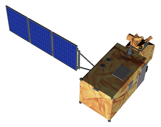
Sentinel-2
Mission and sensor parameters
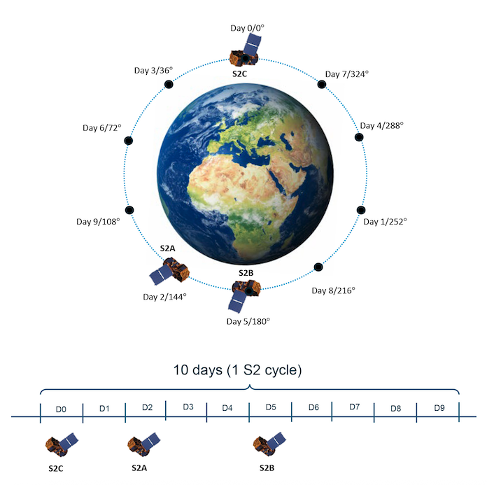
Sentinel-2 is an operational wide-swath (290 km), high-resolution (10 m), multi-spectral (13 bands) imaging satellite with high revisit frequency (5 days) which is part of the Copernicus Programme1. The Sentinel-2 mission comprises a constellation of two polar-orbiting satellites placed in the same sun-synchronous orbit.
Mission parameters
Sentinel-2A was launched on 23 June 2015, Sentinel-2B on 7 March 2017, and Sentinel-2C on 5 September 2024. Each satellite carries a single payload: the Multi-Spectral Instrument (MSI). Once launched, the European Commission assumes ownership of the satellites, and the European Space Agency the role of operator. In the Charter Governance ESA acts as mission owner of Sentinel-2.
Table 1 provides a summary of the Sentinel-2 mission.
| Parameter | Specifications |
|---|---|
| EO Mission | Sentinel-2 |
| Providing Agency | Copernicus, ESA |
| Date of launch | 2015-06-23 |
| Temporal coverage | 2015-06-27 - present |
| Mission status | On Going |
| Mission Life Expected | >10 years |
| Orbit Type | Sun-synchronous |
| Equator crossing Time | 10:30 AM descending node |
| Orbit Height | 786 km |
| Orbit Period | 100.6 min |
| Revisit Frequency | 5 days |
| Nominal Swath Width | 290 km |
Table 1 - Sentinel-2 mission parameters.
Due to the Sentinel-2A Exceptional temporary extension campaign starting in March 2025, additional Sentinel-2 observations will be available on the same relative orbit, occurring 2 days apart from Sentinel-2B and 1 day apart from Sentinel-2C.
Sensor specifications
Below specifications of the Multi-Spectral Instrument (MSI) optical earth observation sensor on board the Sentinel-2 platform.
| Parameter | Specifications |
|---|---|
| Imager Type | Push broom |
| Imaging Mode | 13 MS spectral channels (VIS, NIR, RE, and SWIR) |
Central Wavelength for coastal (B1) |
443 nm |
Central Wavelength for blue (B2) |
493 nm |
Central Wavelength for green (B3) |
560 nm |
Central Wavelength for red (B4) |
665 nm |
Central Wavelength for rededge70 (B5) |
705 nm |
Central Wavelength for rededge74 (B6) |
740 nm |
Central Wavelength for rededge78 (B7) |
783 nm |
Central Wavelength for nir (B8) |
842 nm |
Central Wavelength for nir08 (B8a) |
865 nm |
Central Wavelength for nir09 (B9) |
945 nm |
Central Wavelength for cirrus (B10) |
1375 nm |
Central Wavelength for swir16 (B11) |
1610 nm |
Central Wavelength for swir22 (B12) |
2190 nm |
| Resolution | Medium Resolution - 0-MR (4 - 25m) |
| GSD | 10m (B2,3,4,8), 20m (B5,6,7,8a,11,12) and 60m (B1,9,10) |
| Dynamic Range | 12-bits per pixel |
Table 2 - Sentinel-2 MSI sensor parameters.
Processing levels
Sentinel-2 data is distributed only with Level-1C or Level-2A products. Level-0, Level-1A and Level-1B products are internal products not available to users.
L1C
A Sentinel-2 L1C product contains the following files
S2A_MSIL1C_20220321T072621_N0400_R049_T37KBB_20220321T094304
├── AUX_DATA
├── DATASTRIP
├── GRANULE
│   └── L1C_T37KBB_A035224_20220321T075029
│       └── IMG_DATA
│           ├── T37KBB_20220321T072621_B01.jp2
│           ├── . . .
│           ├── T37KBB_20220321T072621_B12.jp2
│       └── MTD_TL.xml
│       └── QI_DATA
├── HTML
├── INSPIRE.xml
├── manifest.safe
├── MTD_MSIL1C.xml
├── rep_info
└── S2A_MSIL1C_20220321T072621_N0400_R049_T37KBB_20220321T094304-ql.jpg
Under the IMG_DATA directory, a Sentinel-2 L1C product includes 13 multispectral bands (13 single band raster in .jp2 format).
L2A
A Sentinel-2 L2A product contains the following files
S2A_MSIL2A_20220321T072621_N0400_R049_T37KBB_20220321T103727
├── AUX_DATA
├── DATASTRIP
├── GRANULE
│   └── L2A_T37KBB_A035224_20220321T075029
│       ├── IMG_DATA
│           ├── R10m
│               ├── T37KBB_20220321T072621_B02_10m.jp2
│               ├── . . .
│               └── T37KBB_20220321T072621_B08_10m.jp2
│           ├── R20m
│           └── R60m
│       ├── MTD_TL.xml
│       └── QI_DATA
├── HTML
├── INSPIRE.xml
├── manifest.safe
├── MTD_MSIL2A.xml
├── rep_info
└── S2A_MSIL2A_20220321T072621_N0400_R049_T37KBB_20220321T103727-ql.jpg
Under the IMG_DATA directory, a Sentinel-2 L2A product includes 12 multispectral bands resampled at multiple resolutions (25 single band raster in .jp2 format):
-
R10m: B02 (blue), B03 (green), B04 (red), B08 (nir)
-
R20m: B01 (coastal), B02 (blue), B03 (green), B04 (red), B05 (rededge70), B06 (rededge74), B07 (rededge78), B8A (nir08), B11 (swir16), B12 (swir22)
-
R60m: B01 (coastal), B02 (blue), B03 (green), B04 (red), B05 (rededge70), B06 (rededge74), B07 (rededge78), B8A (nir08), B09 (nir09), B11 (swir16), B12 (swir22)
Warning
Cirrus band B10 is not given in L2A products.
Ingested format
Information extracted from product annotation included in the STAC item of a Sentinel-2 L1C dataset are listed below.
Properties
STAC item content about properties for a Sentinel-2 L1C 13-Bands Multispectral Dataset is the following:
  "properties": {
    "platform": "sentinel-2a",
    "constellation": "sentinel-2",
    "mission": "sentinel-2",
    "instruments": [
      "msi"
    ],
    "sensor_type": "optical",
    "gsd": 10,
    "datetime": "2023-07-28T10:26:01.024Z",
    "created": "2023-07-28T19:07:29.0177842Z",
    "updated": "2023-08-17T14:43:34.7533909Z",
    "title": "SENTINEL-2A MSI L1C 108 2023-07-28 10:26:01",
    "processing_baseline": "05.09",
    "providers": [
      {
        "name": "ESA/EC (Copernicus)",
        "description": "The Copernicus Sentinel-2 mission comprises a constellation of two polar-orbiting satellites placed in the same sun-synchronous orbit, phased at 180° to each other. It aims at monitoring variability in land surface conditions, and its wide swath width (290 km) and high revisit time (10 days at the equator with one satellite, and 5 days with 2 satellites under cloud-free conditions which results in 2-3 days at mid-latitudes) will support monitoring of Earth's surface changes.",
        "roles": [
          "producer",
          "processor",
          "licensor"
        ],
        "url":"https://sentinel.esa.int/web/sentinel/missions/sentinel-2"
      }
    ],
    "license": "CC-BY-SA-3.0-IGO",
    "disaster:call_ids": [
      956
    ],
    "disaster:resolution_class": "MR",
    "cpe:cos2_id": "956-ESA-SENTINEL_2A-S2A_MSIL1C_20230728T102601_N0509_R108_T31SEA_20230728T154909",
  }
Satellite
STAC item content about Satellite for a Sentinel-2 L1C Dataset is the following:
  "properties": {
    "sat:orbit_state": "descending",
    "sat:absolute_orbit": 42290,
    "sat:relative_orbit": 108,
    "sat:platform_international_designator": "2015-000A"
}
Processing
STAC item content about Processing for a Sentinel-2 L1C Dataset is the following:
  "properties": {
    "processing:level": "L1C",
    "processing_baseline": "05.09",
    "processing:lineage": "Generation of Level-1C User Product"
  }
Projection
STAC item content about Projection for a Sentinel-2 L1C Dataset is the following:
  "properties": {
    "proj:epsg": 32631
  }
Geometry
STAC item content about Geometry for a Sentinel-2 L1C Dataset is the following:
  "geometry": {
    "type": "Polygon",
    "coordinates": [
      [
        [
          2.999775083171189,
          37.046583050483974
        ],
        [
          2.999775083171189,
          37.046583050483974
        ],
        [
          2.999777933310176,
          36.05672396511734
        ],
        [
          4.218800020089911,
          36.05052821595199
        ],
        [
          2.999775083171189,
          37.046583050483974
        ]
      ]
    ]
  },
  "bbox": [
    2.999775083171189,
    36.05052821595199,
    4.234438031342126,
    37.046583050483974
  ]
Assets
STAC item content about assets (annotation, quicklooks and spectral bands files harvested from the source product) and EO bands for a Sentinel-2 L1C Multispectral Dataset is the following:
  "assets": {
    "mtd": {
      "type": "application/xml",
      "roles": [
        "metadata"
      ],
      "href": "https://.../S2A_MSIL1C_20230728T102601_N0509_R108_T31SEA_20230728T154909/mtd.xml",
      "filename": "S2A_MSIL1C_20230728T102601_N0509_R108_T31SEA_20230728T154909.SAFE/MTD_MSIL1C.xml",
      "file:size": 45698
    },
    "B01": {
      "type": "image/jp2",
      "roles": [
        "data",
        "reflectance"
      ],
      "title": "coastal 443nm TOA 60",
      "href": "https://.../S2A_MSIL1C_20230728T102601_N0509_R108_T31SEA_20230728T154909/B01.jp2",
      "filename": "S2A_MSIL1C_20230728T102601_N0509_R108_T31SEA_20230728T154909.SAFE/GRANULE/L1C_T31SEA_A042290_20230728T103715/IMG_DATA/T31SEA_20230728T102601_B01.jp2",
      "file:size": 3741031,
      "gsd": 60,
      "eo:bands": [
        {
          "name": "coastal",
          "description": "coastal 443nm TOA 60",
          "common_name": "coastal",
          "center_wavelength": 0.4427,
          "solar_illumination": 1884.69
        }
      ],
      "proj:shape": [
        1830,
        1830
      ],
      "raster:bands": [
        {
          "nodata": 0,
          "spatial_resolution": 60,
          "statistics": {
            "minimum": 0,
            "maximum": 10000
          }
        }
      ]
    },
    "B02": {
      "type": "image/jp2",
      "roles": [
        "data",
        "reflectance"
      ],
      "title": "blue 493nm TOA 10",
      "href": "https://.../S2A_MSIL1C_20230728T102601_N0509_R108_T31SEA_20230728T154909/B02.jp2",
      "filename": "S2A_MSIL1C_20230728T102601_N0509_R108_T31SEA_20230728T154909.SAFE/GRANULE/L1C_T31SEA_A042290_20230728T103715/IMG_DATA/T31SEA_20230728T102601_B02.jp2",
      "file:size": 105535720,
      "gsd": 10,
      "eo:bands": [
        {
          "name": "blue",
          "description": "blue 493nm TOA 10",
          "common_name": "blue",
          "center_wavelength": 0.49269999999999997,
          "solar_illumination": 1959.66
        }
      ],
      "proj:shape": [
        10980,
        10980
      ],
      "raster:bands": [
        {
          "nodata": 0,
          "spatial_resolution": 10,
          "statistics": {
            "minimum": 0,
            "maximum": 10000
          }
        }
      ]
    },
    "B03": {
      "type": "image/jp2",
      "roles": [
        "data",
        "reflectance"
      ],
      "title": "green 560nm TOA 10",
      "href": "https://.../S2A_MSIL1C_20230728T102601_N0509_R108_T31SEA_20230728T154909/B03.jp2",
      "filename": "S2A_MSIL1C_20230728T102601_N0509_R108_T31SEA_20230728T154909.SAFE/GRANULE/L1C_T31SEA_A042290_20230728T103715/IMG_DATA/T31SEA_20230728T102601_B03.jp2",
      "file:size": 104917503,
      "gsd": 10,
      "eo:bands": [
        {
          "name": "green",
          "description": "green 560nm TOA 10",
          "common_name": "green",
          "center_wavelength": 0.5598,
          "solar_illumination": 1823.24
        }
      ],
      "proj:shape": [
        10980,
        10980
      ],
      "raster:bands": [
        {
          "nodata": 0,
          "spatial_resolution": 10,
          "statistics": {
            "minimum": 0,
            "maximum": 10000
          }
        }
      ]
    },
    "B04": {
      "type": "image/jp2",
      "roles": [
        "data",
        "reflectance"
      ],
      "title": "red 665nm TOA 10",
      "href": "https://.../S2A_MSIL1C_20230728T102601_N0509_R108_T31SEA_20230728T154909/B04.jp2",
      "filename": "S2A_MSIL1C_20230728T102601_N0509_R108_T31SEA_20230728T154909.SAFE/GRANULE/L1C_T31SEA_A042290_20230728T103715/IMG_DATA/T31SEA_20230728T102601_B04.jp2",
      "file:size": 107620075,
      "gsd": 10,
      "eo:bands": [
        {
          "name": "red",
          "description": "red 665nm TOA 10",
          "common_name": "red",
          "center_wavelength": 0.6646,
          "solar_illumination": 1512.06
        }
      ],
      "proj:shape": [
        10980,
        10980
      ],
      "raster:bands": [
        {
          "nodata": 0,
          "spatial_resolution": 10,
          "statistics": {
            "minimum": 0,
            "maximum": 10000
          }
        }
      ]
    },
    "B05": {
      "type": "image/jp2",
      "roles": [
        "data",
        "reflectance"
      ],
      "title": "rededge 704nm TOA 20",
      "href": "https://.../S2A_MSIL1C_20230728T102601_N0509_R108_T31SEA_20230728T154909/B05.jp2",
      "filename": "S2A_MSIL1C_20230728T102601_N0509_R108_T31SEA_20230728T154909.SAFE/GRANULE/L1C_T31SEA_A042290_20230728T103715/IMG_DATA/T31SEA_20230728T102601_B05.jp2",
      "file:size": 31410148,
      "gsd": 20,
      "eo:bands": [
        {
          "name": "rededge70",
          "description": "rededge 704nm TOA 20",
          "common_name": "rededge",
          "center_wavelength": 0.7041000000000001,
          "solar_illumination": 1424.64
        }
      ],
      "proj:shape": [
        5490,
        5490
      ],
      "raster:bands": [
        {
          "nodata": 0,
          "spatial_resolution": 20,
          "statistics": {
            "minimum": 0,
            "maximum": 10000
          }
        }
      ]
    },
    "B06": {
      "type": "image/jp2",
      "roles": [
        "data",
        "reflectance"
      ],
      "title": "rededge 740nm TOA 20",
      "href": "https://.../S2A_MSIL1C_20230728T102601_N0509_R108_T31SEA_20230728T154909/B06.jp2",
      "filename": "S2A_MSIL1C_20230728T102601_N0509_R108_T31SEA_20230728T154909.SAFE/GRANULE/L1C_T31SEA_A042290_20230728T103715/IMG_DATA/T31SEA_20230728T102601_B06.jp2",
      "file:size": 31491499,
      "gsd": 20,
      "eo:bands": [
        {
          "name": "rededge74",
          "description": "rededge 740nm TOA 20",
          "common_name": "rededge",
          "center_wavelength": 0.7405,
          "solar_illumination": 1287.61
        }
      ],
      "proj:shape": [
        5490,
        5490
      ],
      "raster:bands": [
        {
          "nodata": 0,
          "spatial_resolution": 20,
          "statistics": {
            "minimum": 0,
            "maximum": 10000
          }
        }
      ]
    },
    "B07": {
      "type": "image/jp2",
      "roles": [
        "data",
        "reflectance"
      ],
      "title": "rededge 783nm TOA 20",
      "href": "https://.../S2A_MSIL1C_20230728T102601_N0509_R108_T31SEA_20230728T154909/B07.jp2",
      "filename": "S2A_MSIL1C_20230728T102601_N0509_R108_T31SEA_20230728T154909.SAFE/GRANULE/L1C_T31SEA_A042290_20230728T103715/IMG_DATA/T31SEA_20230728T102601_B07.jp2",
      "file:size": 31633336,
      "gsd": 20,
      "eo:bands": [
        {
          "name": "rededge78",
          "description": "rededge 783nm TOA 20",
          "common_name": "rededge",
          "center_wavelength": 0.7827999999999999,
          "solar_illumination": 1162.08
        }
      ],
      "proj:shape": [
        5490,
        5490
      ],
      "raster:bands": [
        {
          "nodata": 0,
          "spatial_resolution": 20,
          "statistics": {
            "minimum": 0,
            "maximum": 10000
          }
        }
      ]
    },
    "B08": {
      "type": "image/jp2",
      "roles": [
        "data",
        "reflectance"
      ],
      "title": "nir 833nm TOA 10",
      "href": "https://.../S2A_MSIL1C_20230728T102601_N0509_R108_T31SEA_20230728T154909/B08.jp2",
      "filename": "S2A_MSIL1C_20230728T102601_N0509_R108_T31SEA_20230728T154909.SAFE/GRANULE/L1C_T31SEA_A042290_20230728T103715/IMG_DATA/T31SEA_20230728T102601_B08.jp2",
      "file:size": 109139390,
      "gsd": 10,
      "eo:bands": [
        {
          "name": "nir",
          "description": "nir 833nm TOA 10",
          "common_name": "nir",
          "center_wavelength": 0.8328,
          "solar_illumination": 1041.63
        }
      ],
      "proj:shape": [
        10980,
        10980
      ],
      "raster:bands": [
        {
          "nodata": 0,
          "spatial_resolution": 10,
          "statistics": {
            "minimum": 0,
            "maximum": 10000
          }
        }
      ]
    },
    "B09": {
      "type": "image/jp2",
      "roles": [
        "data",
        "reflectance"
      ],
      "title": "nir09 945nm TOA 60",
      "href": "https://.../S2A_MSIL1C_20230728T102601_N0509_R108_T31SEA_20230728T154909/B09.jp2",
      "filename": "S2A_MSIL1C_20230728T102601_N0509_R108_T31SEA_20230728T154909.SAFE/GRANULE/L1C_T31SEA_A042290_20230728T103715/IMG_DATA/T31SEA_20230728T102601_B09.jp2",
      "file:size": 3751462,
      "gsd": 60,
      "eo:bands": [
        {
          "name": "nir09",
          "description": "nir09 945nm TOA 60",
          "common_name": "nir09",
          "center_wavelength": 0.9451,
          "solar_illumination": 812.92
        }
      ],
      "proj:shape": [
        1830,
        1830
      ],
      "raster:bands": [
        {
          "nodata": 0,
          "spatial_resolution": 60,
          "statistics": {
            "minimum": 0,
            "maximum": 10000
          }
        }
      ]
    },
    "B10": {
      "type": "image/jp2",
      "roles": [
        "data",
        "reflectance"
      ],
      "title": "cirrus 1374nm TOA 60",
      "href": "https://.../S2A_MSIL1C_20230728T102601_N0509_R108_T31SEA_20230728T154909/B10.jp2",
      "filename": "S2A_MSIL1C_20230728T102601_N0509_R108_T31SEA_20230728T154909.SAFE/GRANULE/L1C_T31SEA_A042290_20230728T103715/IMG_DATA/T31SEA_20230728T102601_B10.jp2",
      "file:size": 3238033,
      "gsd": 60,
      "eo:bands": [
        {
          "name": "cirrus",
          "description": "cirrus 1374nm TOA 60",
          "common_name": "cirrus",
          "center_wavelength": 1.3735,
          "solar_illumination": 367.15
        }
      ],
      "proj:shape": [
        1830,
        1830
      ],
      "raster:bands": [
        {
          "nodata": 0,
          "spatial_resolution": 60,
          "statistics": {
            "minimum": 0,
            "maximum": 10000
          }
        }
      ]
    },
    "B11": {
      "type": "image/jp2",
      "roles": [
        "data",
        "reflectance"
      ],
      "title": "swir16 1614nm TOA 20",
      "href": "https://.../S2A_MSIL1C_20230728T102601_N0509_R108_T31SEA_20230728T154909/B11.jp2",
      "filename": "S2A_MSIL1C_20230728T102601_N0509_R108_T31SEA_20230728T154909.SAFE/GRANULE/L1C_T31SEA_A042290_20230728T103715/IMG_DATA/T31SEA_20230728T102601_B11.jp2",
      "file:size": 29995805,
      "gsd": 20,
      "eo:bands": [
        {
          "name": "swir16",
          "description": "swir16 1614nm TOA 20",
          "common_name": "swir16",
          "center_wavelength": 1.6137000000000001,
          "solar_illumination": 245.59
        }
      ],
      "proj:shape": [
        5490,
        5490
      ],
      "raster:bands": [
        {
          "nodata": 0,
          "spatial_resolution": 20,
          "statistics": {
            "minimum": 0,
            "maximum": 10000
          }
        }
      ]
    },
    "B12": {
      "type": "image/jp2",
      "roles": [
        "data",
        "reflectance"
      ],
      "title": "swir22 2202nm TOA 20",
      "href": "https://.../S2A_MSIL1C_20230728T102601_N0509_R108_T31SEA_20230728T154909/B12.jp2",
      "filename": "S2A_MSIL1C_20230728T102601_N0509_R108_T31SEA_20230728T154909.SAFE/GRANULE/L1C_T31SEA_A042290_20230728T103715/IMG_DATA/T31SEA_20230728T102601_B12.jp2",
      "file:size": 30290921,
      "gsd": 20,
      "eo:bands": [
        {
          "name": "swir22",
          "description": "swir22 2202nm TOA 20",
          "common_name": "swir22",
          "center_wavelength": 2.2024,
          "solar_illumination": 85.25
        }
      ],
      "proj:shape": [
        5490,
        5490
      ],
      "raster:bands": [
        {
          "nodata": 0,
          "spatial_resolution": 20,
          "statistics": {
            "minimum": 0,
            "maximum": 10000
          }
        }
      ]
    },
    "B8A": {
      "type": "image/jp2",
      "roles": [
        "data",
        "reflectance"
      ],
      "title": "nir08 865nm TOA 20",
      "href": "https://.../S2A_MSIL1C_20230728T102601_N0509_R108_T31SEA_20230728T154909/B8A.jp2",
      "filename": "S2A_MSIL1C_20230728T102601_N0509_R108_T31SEA_20230728T154909.SAFE/GRANULE/L1C_T31SEA_A042290_20230728T103715/IMG_DATA/T31SEA_20230728T102601_B8A.jp2",
      "file:size": 32057732,
      "gsd": 20,
      "eo:bands": [
        {
          "name": "nir08",
          "description": "nir08 865nm TOA 20",
          "common_name": "nir08",
          "center_wavelength": 0.8647,
          "solar_illumination": 955.32
        }
      ],
      "proj:shape": [
        5490,
        5490
      ],
      "raster:bands": [
        {
          "nodata": 0,
          "spatial_resolution": 20,
          "statistics": {
            "minimum": 0,
            "maximum": 10000
          }
        }
      ]
    },
    "PVI": {
      "type": "image/jp2",
      "roles": [
        "overview"
      ],
      "href": "https://.../S2A_MSIL1C_20230728T102601_N0509_R108_T31SEA_20230728T154909/PVI.jp2",
      "filename": "S2A_MSIL1C_20230728T102601_N0509_R108_T31SEA_20230728T154909.SAFE/GRANULE/L1C_T31SEA_A042290_20230728T103715/QI_DATA/T31SEA_20230728T102601_PVI.jp2",
      "file:size": 166314
    },
    "TCI": {
      "type": "image/jp2",
      "roles": [
        "data",
        "reflectance"
      ],
      "href": "https://.../S2A_MSIL1C_20230728T102601_N0509_R108_T31SEA_20230728T154909/TCI.jp2",
      "filename": "S2A_MSIL1C_20230728T102601_N0509_R108_T31SEA_20230728T154909.SAFE/GRANULE/L1C_T31SEA_A042290_20230728T103715/IMG_DATA/T31SEA_20230728T102601_TCI.jp2",
      "file:size": 110774289
    },
    "manifest": {
      "type": "text/xml",
      "roles": [
        "metadata"
      ],
      "title": "SAFE Manifest",
      "href": "https://.../S2A_MSIL1C_20230728T102601_N0509_R108_T31SEA_20230728T154909/manifest.safe",
      "filename": "S2A_MSIL1C_20230728T102601_N0509_R108_T31SEA_20230728T154909.SAFE/manifest.safe",
      "file:size": 48687
    },
    "thumbnail": {
      "type": "image/jpeg",
      "roles": [
        "thumbnail"
      ],
      "title": "Acquisition Thumbnail",
      "href": "https://.../S2A_MSIL1C_20230728T102601_N0509_R108_T31SEA_20230728T154909/thumbnail.jpg"
    }
  },
Product Calibration
For Sentinel-2 products calibration refer to the Optical Products Calibration (OPT-Calib) service and the calibration sheet available here.
-
ESA, Sentinel Online, Sentinel-2 Mission Guide. Available at: sentinel.esa.int ↩