HASARD Dual Image service specifications
![]()
This service provides a binary flood mask by applying an automatic change detection algorithm between a pair of pre- and post-event Sentinel-1 datasets selected by the user (one before and one after the event). The service analyzes the reference and flooded images and retrieves the increased water extent with respect to the reference (areas considered as standing water bodies are removed).
 The tutorial of the HASARD Dual Image service is available in this section.
Service Description
The HASARD Dual Image service performs a flood mapping computation between two SAR Calibrated Datasets selected by the user (one before and one after the event).
The “HASARD”1 flood mapping algorithm enables systematic, automatic and reliable SAR mapping of terrestrial water bodies. The HASARD Dual Image service implements the Hierarchical Split-Based Approach (HSBA), described by Chini et al. 20172, and is specifically designed to support flooding-related disaster risk reduction at global scale. The underlying end-to-end image processing chain is based on a patented technology from the Luxembourg Institute of Science and Technology (LIST)3 that combines and fully integrates innovative hierarchical image splitting and open water backscatter modelling. The service is developed by LIST and WASDI.
The HASARD Dual Image processor exploits pairs of satellite images (flood and reference from Ground Range Detected calibrated data) to systematically, rapidly and automatically produce, record and disseminate accurate floodwater maps. Output flood maps are obtained by applying an automatic unsupervised Change Detection algorithm to pairs of SAR images only over pixels which are classified as non-permanent water bodies.
The result is a binary raster bitmask with the potential flooded area in the disaster zones. This binary mask represents the increased water extent with respect to the reference (areas considered as standing water bodies are removed). It also provides co-located Sigma Nought assets in dB at the same polarisation derived from the two input datasets.
Note
This service currently supports only Sentinel-1 data.
Workflow
The processing service applies the workflow below:
Input
Input of the HASARD Dual Image service is a couple of co-pol Sigma0 images in dB from Calibrated Dataset [CD] obtained from the Radar Calibration processor. This pair shall be made of the following Datasets:
-
Secondary SAR Calibrated Dataset including a co-pol Sigma Nought asset in dB (e.g.
s0_db_c_vvfor Sentinel-1) acquired during crisis, -
Reference SAR Calibrated Dataset including a co-pol Sigma Nought asset in dB (e.g.
s0_db_c_vvfor Sentinel-1) acquired before the event.
Warning
HASARD requires as input a couple of Sigma0 co-pol assets in dB from SAR calibrated dataset. Such image pairs must come from the same sensor and shall have the same radar geometry (incident angle, orbit path). Input Flood and Reference backscatter images must be both in VV polarisation.
Warning
This service does not support SAR complex data (e.g. Sentinel-1 SLC).
Parameters
The HASARD Dual Image service requires a specified number of mandatory and optional parameters. All service parameters are listed in the below Table 1.
| Parameter | Description | Required | Default value |
|---|---|---|---|
| Flood event calibrated dataset | Secondary SAR Calibrated Dataset including a post-event Sigma0 in db asset | YES | |
| Reference calibrated dataset | Reference SAR Calibrated Dataset including a pre-event Sigma0 in db asset | YES | |
| Splitting level | Hierarchical level of splitting. When the level is equal to 1 the image is split into 4 tiles, equal to 2 in 16 tiles, equal to 3 in 64 tiles, etc. |
YES | 3 |
| Check bimodal distribution (Ashman D) | Ashman D coefficient to be used to check bimodal distribution | YES | 2.4 |
| Minimum number of pixels per tile | Minimum number of pixels per tile for checking the bimodality hypothesis | YES | 1000 |
| Number of pixels for small object removal | Number of pixels for small objects (blobs) removal | YES | 20 |
| Area of Interest | Area of interest expressed in WKT | NO |
Table 1 - Service parameters for the HASARD Dual Image processor.
Flood and Reference SAR calibrated datasets
First two mandatory parameters are dedicated to define input "Flood" and "Reference" co-pol backscatter images from SAR Calibrated Datasets. This pair must come from the same sensor and shall have the same radar geometry (incident angle, orbit path). Input for Flood event image and Reference event image parameters are the references to the Calibrated Datasets. The system will automatically select the co-pol asset from the given Calibrated Dataset to be used in the computation.
Warning
The drag and drop of the single-band asset (e.g. "s0_db_c_vv") is not possible. Users must drag and drop only a Calibrated Dataset (e.g. "[CD] SENTINEL-1A C-SAR IW VV/VH 134 2021/11/06 21:43:07") into both Flood event image and Reference event image fields.
HSBA parameters
The other four mandatory parameters, Splitting level, Check bimodal distribution (Ashman D), Minimum number of pixels per tile, and Number of pixels for small object removal represents the parameters of the retrieval algorithm. Default values given in Table 1 are recommended to be used for these four HSBA parameters.
AOI (optional)
This last parameter (optional) may define the area of interest expressed as a Well-Known Text value. If set, it overrides the automatic determination of the maximum common area between the input-reference products geometry.
Warning
The input area of interest must have an area higher than 1600 skm or 160000 ha. If a smaller area is inserted the job will not be executed and a warning will appear.
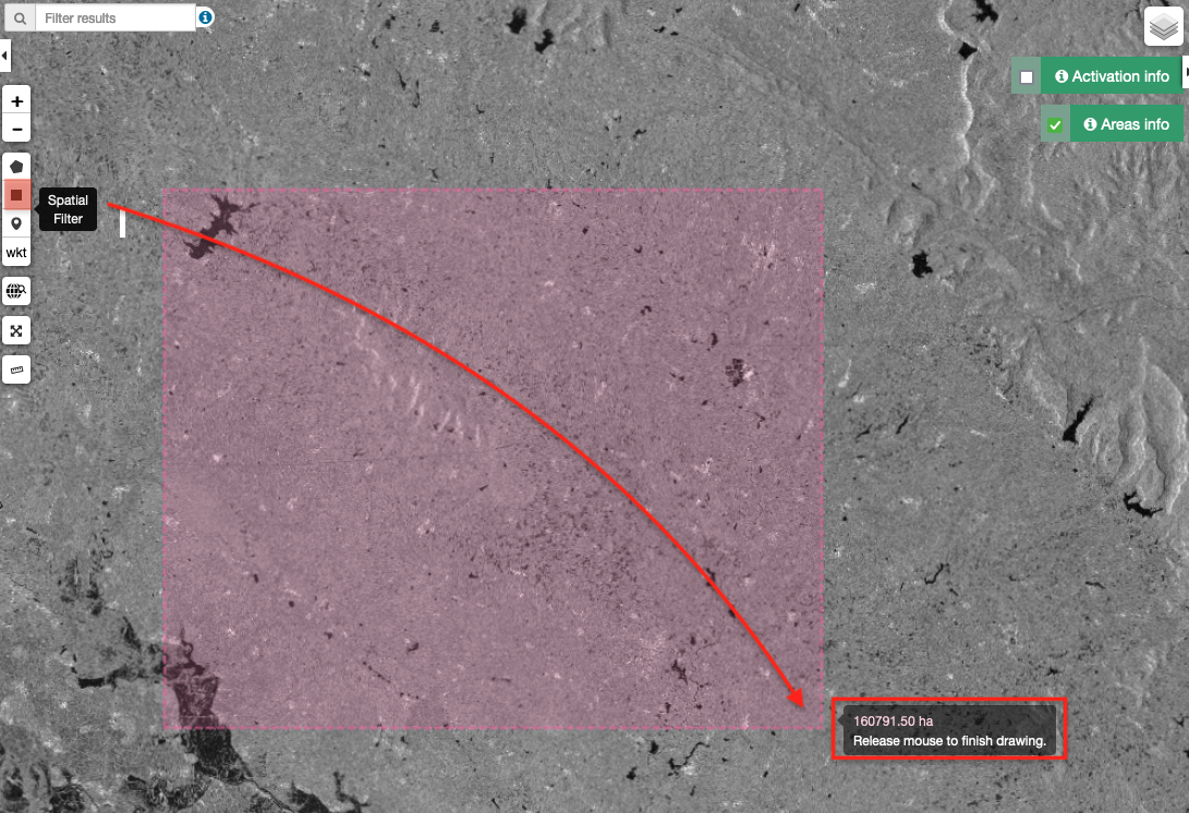
Tip
An AOI higher than 160000 ha can be easily drawn in the ESA Charter Mapper by using the Spatial Filter button available in the Navigation and Search Toolbar in the upper left side of the map. During the drawing of the rectangular area, a popup showing the size of the current area in ha will appear in the map next to the cursor.
Tip
In the definition of “Area of interest as Well Known Text” it is possible to apply as AOI the drawn polygon defined with the area filter. To do so, click on the button in the left side of the "Area of interest expressed as Well-known text" box and select the option AOI from the list. The platform will automatically fill the parameter value with the rectangular bounding box taken from the current search area in WKT format.
Output
The HASARD Dual Image processor provides as output the following products:
-
Flood binary mask
-
Flood extent mapping overview
-
Sigma nought in dB from secondary calibrated dataset
-
Grayscale overview from secondary sigma nought co-pol asset
-
Sigma nought in dB from reference calibrated dataset
-
Grayscale overview from reference sigma nought co-pol asset
HASARD Dual Image Product Specifications can be found in the below tables.
| Attribute | Value / description |
|---|---|
| Long Name | Flood Binary flood mask from HASARD Dual Image |
| Short Name | flood-mask |
| Description | Flood bitmask: 1=Flooded, 0 =Not-flooded |
| Processing level | L2 |
| Data Type | UnSigned 8-bit Integer |
| Band | 1 |
| Format | COG |
| Projection | Native or EPSG:4326 - WGS84 |
| Valid Range | [0 - 1] |
| Fill Value | N/A |
| Attribute | Value / description |
|---|---|
| Long Name | SAR Amplitude Change RGB composite |
| Short Name | overview-flood-mask |
| Description | Flood bitmask in the blue channel including transparency |
| Processing level | L2 |
| Data Type | UnSigned 8-bit Integer |
| Band | 4 |
| Format | COG |
| Projection | Native or EPSG:4326 - WGS84 |
| Valid Range | [1 - 255] |
| Fill Value | 0 |
| Attribute | Value / description |
|---|---|
| Long Name | Secondary Sigma Nought Asset in dB |
| Short Name | s0_db_c_vv-post |
| Description | Single-band Sigma Nought asset in dB from the SAR Calibrated Dataset acquired during the crisis |
| Processing level | L1 |
| Data Type | Float 32 bit |
| Band | Single for each polarization |
| Format | COG |
| Projection | Native or EPSG:4326 - WGS84 |
| Units | dB |
| Attribute | Value / description |
|---|---|
| Long Name | Full resolution grayscale overview of secondary sigma nought asset |
| Short Name | overview-pp-post (where "pp" stands for polarization e.g. hh or vv) |
| Description | Grayscale RGBA from the secondary Sigma Nought co-pol asset (including alpha band) |
| Processing level | L1 |
| Data Type | UnSigned 8-bit Integer |
| Band | 4 |
| Format | COG |
| Projection | Native or EPSG:4326 - WGS84 |
| Valid Range | [1 - 255] |
| Fill Value | 0 |
| Attribute | Value / description |
|---|---|
| Long Name | Reference Sigma Nought Asset in dB |
| Short Name | s0_db_c_vv-pre |
| Description | Single-band Sigma Nought asset in dB from the SAR Calibrated Dataset acquired before the event |
| Processing level | L1 |
| Data Type | Float 32 bit |
| Band | Single for each polarization |
| Format | COG |
| Projection | Native or EPSG:4326 - WGS84 |
| Units | dB |
| Attribute | Value / description |
|---|---|
| Long Name | Full resolution grayscale overview of reference sigma nought asset |
| Short Name | overview-vv-pre |
| Description | Grayscale RGBA from the reference Sigma Nought co-pol asset (including alpha band) |
| Processing level | L1 |
| Data Type | UnSigned 8-bit Integer |
| Band | 4 |
| Format | COG |
| Projection | Native or EPSG:4326 - WGS84 |
| Valid Range | [1 - 255] |
| Fill Value | 0 |
Vectorize HASARD flood mask single band asset
HASARD-DI's binary flood mask can be spatially filtered and / or converted to polygon using the FilterVectorize service.
To polygonize the flood-mask single band asset employ the FilterVectorize service in Vectorize mode by selecting only true values DN=1 (flood).
If not satisfied with the spatial filtering offered by the HASARD Dual Image service with the Number of pixels for small object removal parameter, the FilterVectorize service can be used to further post-process the binary mask and remove small isolated clusters of flooded pixels. Thus to obtained further spatially filtered flood extent vector employ the FilterVectorize service in the Filter and Vectorize mode.
Warning
Only the flood-mask single band asset can be used in the FilterVectorize on-demand service, being the only discrete raster produced by the HASARD Dual Image service.
-
LIST, An automatic satellite image processing tool for flood hazard prevention on a global scale, available at www.list.lu. ↩
-
M. Chini, R. Hostache, L. Giustarini and P. Matgen (2017), "A Hierarchical Split-Based Approach for Parametric Thresholding of SAR Images: Flood Inundation as a Test Case," in IEEE Transactions on Geoscience and Remote Sensing, vol. 55, no. 12, pp. 6975-6988, Dec. 2017, DOI: 10.1109/TGRS.2017.2737664. ↩
-
LIST, HASARD developed by the Remote Sensing and Natural Resources Modelling group of the Environmental Research and Innovation Department, available at www.list.lu. ↩