InSAR Browse service specifications
![]()
This service employs SAR calibration, InSAR and offset tracking techniques to derive from a Sentinel-1 SLC pair in IW mode multiple high resolution visual products using terrain corrected interferometric coherence and phase, and reference/secondary sigma nought. The service is built on the Integrated Wide Area Processor (IWAP) InSAR processor which is DLR proprietary software.
 The tutorial of the Sentinel-1 InSAR Browse (InSAR Browse) service is available in this section.
Service Description
The DLR's Sentinel-1 InSAR Browse (InSAR Browse) service derives multiple visual products from a Sentinel-1 SLC pair in IW mode using reference and secondary sigma nought, and terrain corrected interferometric coherence and phase.
This service is meant to be used mainly over seismic and volcanic risk areas for inter- and post-seismic, and pre- and post-eruption monitoring.
The InSAR Browse service is based on the Integrated Wide Area Processor (IWAP) InSAR processor1 which is DLR proprietary software.
In total it generates a total of 10 visual products for:
-
Reference and Secondary Backscatter,
-
Amplitude Change Composite,
-
Interferometric Phase,
-
Interferometric Coherence,
-
Coherence Amplitude Composite,
-
Shifts in azimuth and range.
which are given as 8-bit RGBA or single band grayscale browse products.
Colourbar images for all layers are listed below.
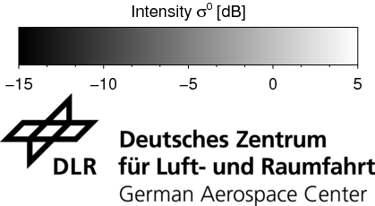
- Legend and colourbar for Master/Slave Amplitude assets
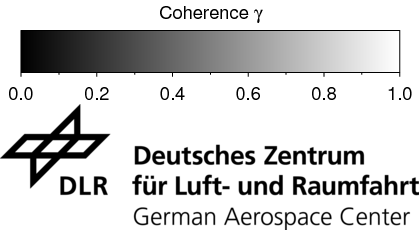
- Legend and colourbar for Coherence Terrain Corrected asset
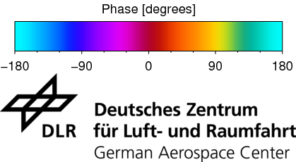
- Legend and colourbar for Interferometric Phase Terrain Corrected asset
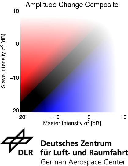
- Legend and colourbar for Amplitude Change Composite asset
- legend and colourbar for Coherence Amplitude Composite asset
- Legend and colourbar for Azimuth and Range shifts assets
Inputs
Input of the InSAR Browse service is an interferometric pair as pair of SLC Datasets from the systematic Radar products Calibration.
Note
This service supports only Complex Radar EO data.
Warning
InSAR Browse supports only SLC Datasets from the Sentinel-1 mission.
Warning
The input pair shall have a temporal baseline not less than the minimum of 6 days and not greater than the maximum of 24 days.
Parameters
The InSAR Browse service requires mandatory and optional parameters. All service parameters are listed in the below Table 1.
| Parameter | Description | Required | Default value |
|---|---|---|---|
| Reference Sentinel-1 SLC Dataset | Input reference SLC Dataset from Sentinel-1 mission in IW mode | YES | |
| Secondary Sentinel-1 SLC Dataset | Input secondary SLC Dataset from Sentinel-1 mission in IW mode | YES |
Table 1 - Service parameters for the InSAR Browse processor.
Reference and secondary SLC Datasets
The reference and secondary SLC Datasets must come from the same sensor (Sentinel-1) and shall have the same radar geometry (incident angle, orbit path, relative orbit).
The overlap of the input products footprint must be at least 40%. The temporal baseline of the interferometric pair shall be of maximum 24 days.
Outputs
The InSAR Browse processor service generates the following 10 visual products which are given as RGBA or single band full resolution browse at 8 bits:
-
Product A: Reference Backscatter browse
-
Product B: Secondary Backscatter browse
-
Product C: Amplitude Change Composite
-
Product D: Terrain Corrected Coherence RGBA
-
Product E: Terrain Corrected Coherence grayscale single band browse
-
Product F: Coherence Amplitude Composite
-
Product G: Terrain Corrected Interferometric Phase RGBA
-
Product H: Terrain Corrected Interferometric Phase as grayscale single band browse
-
Product I: Shifts Azimuth RGBA
-
Product J: Shifts Range RGBA
InSAR Browse Product Specifications can be found in the below tables.
| Attribute | Value / description |
|---|---|
| Long Name | Reference backscatter browse |
| Short Name | geo_ampl_cal_ql_master |
| Description | Grayscale browse product at full resolution from secondary sigma nought in decibel scale after contrast enhancement of [-15,5] dB and rescaling to byte values on [0,255] given as RGBA (R=G=B). |
| Data Type | UInt8 |
| Band | 4 |
| Format | COG |
| Projection | WGS84 Geographic EPSG:4326 |
| Valid Range | [0-255] |
| Attribute | Value / description |
|---|---|
| Long Name | Secondary backscatter browse |
| Short Name | geo_ampl_cal_ql_slave |
| Description | Grayscale browse product at full resolution from secondary sigma nought in decibel scale after contrast enhancement of [-15,5] dB and rescaling to byte values on [0,255] given as RGBA (R=G=B). |
| Data Type | UInt8 |
| Band | 4 |
| Format | COG |
| Projection | WGS84 Geographic EPSG:4326 |
| Valid Range | [0-255] |
| Attribute | Value / description |
|---|---|
| Long Name | Amplitude Change Composite |
| Short Name | geo_ampl_change |
| Description | Red-Blue composite at full resolution (RGBA) from Secondary (R) and Reference (B) and sigma nought in decibel scale after contrast enhancement of [-20,10] dB and rescaling to byte values on [0,255]. |
| Data Type | UInt8 |
| Bands | 4 |
| Format | COG |
| Projection | WGS84 Geographic EPSG:4326 |
| Units | N.A. |
| Valid Range | [0-255] |
| Attribute | Value / description |
|---|---|
| Long Name | Terrain corrected interferometric coherence RGBA |
| Short Name | geo_dcoher |
| Description | Grayscale browse product at full resolution from interferometric coherence on [0,1] scaled to byte values on [0,255] given as RGBA (R=G=B). |
| Data Type | UInt8 |
| Band | 4 |
| Format | COG |
| Projection | WGS84 Geographic EPSG:4326 |
| Valid Range | [0-255] |
| Attribute | Value / description |
|---|---|
| Long Name | Terrain corrected interferometric coherence grayscale single band browse |
| Short Name | geo_dcoher_byte |
| Description | Grayscale single-band browse product at full resolution from interferometric coherence on [0,1] scaled to byte values on [0,255]. |
| Data Type | UInt8 |
| Band | single |
| Format | COG |
| Projection | WGS84 Geographic EPSG:4326 |
| Valid Range | [0-255] |
| Attribute | Value / description |
|---|---|
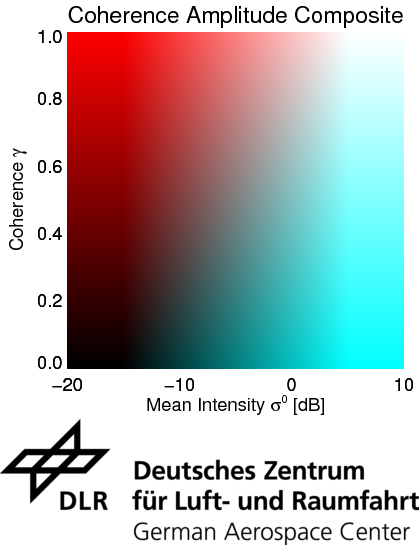
| Long Name | Coherence Amplitude Composite |
| Short Name | geo_coher_ampl |
| Description | Red-Cyan composite browse product at full resolution (RGBA) from Interferometric Coherence (Red channel) and Average Sigma Nought between Reference and Secondary backscatter (Green and Blue channels). For backscatter average a contrast enhancement of [-20,10] dB is applied. Both coherence and backscatter values are rescaled to byte values on [0,255]. |
| Data Type | UInt8 |
| Band | 4 |
| Format | COG |
| Projection | WGS84 Geographic EPSG:4326 |
| Units | N.A. |
| Valid Range | [0-255] |
| Attribute | Value / description |
|---|---|
| Long Name | Terrain corrected interferometric phase RGBA |
| Short Name | geo_dphase |
| Description | Multicolor browse product at full resolution (RGBA) from interferometric phase in degrees [-180,180] rescaled to byte values on [0,255]. |
| Data Type | UInt8 |
| Band | 4 |
| Format | COG |
| Projection | WGS84 Geographic EPSG:4326 |
| Valid Range | [0,255] |
| Attribute | Value / description |
|---|---|
| Long Name | Terrain corrected interferometric phase grayscale single band browse |
| Short Name | geo_dphase_byte |
| Description | Single band grayscale browse product at full resolution from interferometric phase in degrees [-180,180] rescaled to byte values on [0,255]. |
| Data Type | UInt8 |
| Band | 1 |
| Format | COG |
| Projection | WGS84 Geographic EPSG:4326 |
| Valid Range | N.A. |
| Attribute | Value / description |
|---|---|
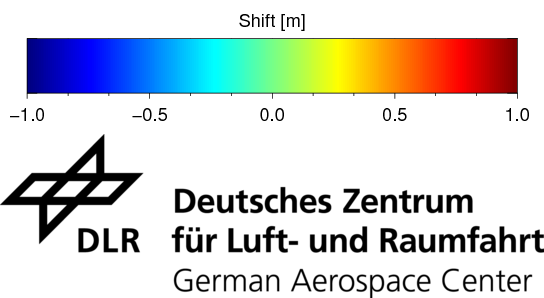
| Long Name | Azimuth shifts RGBA |
| Short Name | geo_shifts_az |
| Description | Multicolor browse product at full resolution (RGBA) from azimuth shifts in metres within [-1,1] m rescaled to byte values on [0,255]. |
| Data Type | UInt8 |
| Band | 4 |
| Format | COG |
| Projection | WGS84 Geographic EPSG:4326 |
| Valid Range | [0,255] |
| Attribute | Value / description |
|---|---|
| Long Name | Range shifts RGBA |
| Short Name | geo_shifts_rg |
| Description | Multicolor browse product at full resolution (RGBA) from range shifts in metres within [-1,1] m rescaled to byte values on [0,255]. |
| Data Type | UInt8 |
| Band | 4 |
| Format | COG |
| Projection | WGS84 Geographic EPSG:4326 |
| Units | [0,255] |
| Valid Range | Azimuth shifts RGBA |
-
Rodriguez Gonzalez, F.; Adam, N.; Parizzi, A.; Brcic, R. The Integrated Wide Area Processor (IWAP): A Processor for Wide Area Persistent Scatterer Interferometry. In Proceedings of the ESA Living Planet Symposium 2013; ESA: Edinburgh, UK, 2013; pp. 1–4. Available at: https://livingplanet2013.org and https://elib.dlr.de. ↩